Weather
National Weather Service
Apr 04, 2026
No watches are valid as of Sat Apr 4 17:52:01 UTC 2026.
Apr 04, 2026
MD 0358 CONCERNING SEVERE POTENTIAL...WATCH POSSIBLE FOR CENTRAL AND NORTHERN OHIO TOWARD LAKE ERIE AND VICINITY
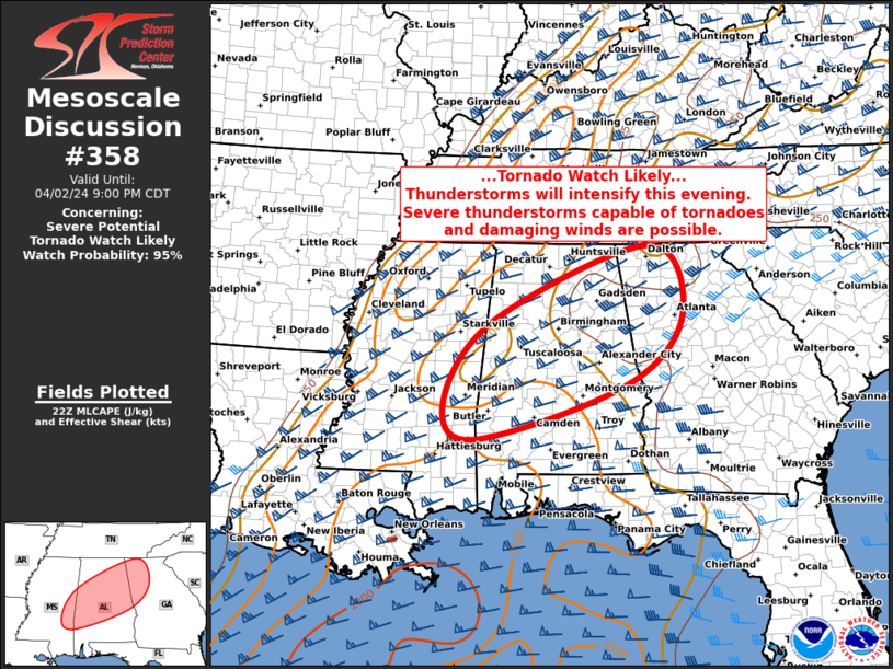
Mesoscale Discussion 0358
NWS Storm Prediction Center Norman OK
1246 PM CDT Sat Apr 04 2026

Areas affected...central and northern Ohio toward Lake Erie and
Vicinity

Concerning...Severe potential...Watch possible

Valid 041746Z - 042015Z

Probability of Watch Issuance...60 percent

SUMMARY...Thunderstorms will develop over the next few hours, with
areas of strong to damaging gusts possible. A brief tornado cannot
be ruled out near the warm front.

DISCUSSION...A composite cold front, reinforced by outflow from
ongoing rain, is nearing the IN/OH border, and extending south
across the OH River. Meanwhile, a warm front is moving into extreme
southeast Lower MI, and extending east across Lake Erie and into far
southwestern NY.

Strong heating has already steepened low-level lapse rates across
the warm sector, resulting in strong southerly wind gusts to 30 kt.
As warming persists, the air mass will destabilize further, with
MLCAPE to around 1000 J/kg expected.

While deep-layer mean wind fields are substantial with 40-50 kt
speeds common aloft, shear is a bit marginal. Another mitigating
factor is a midlevel subsidence inversion, which is reducing overall
CAPE.

Despite this, the leading north-south outflow boundary will serve as
a focus for renewed development over the next few hours. Additional
storms may form in the warm sector as the air mass becomes uncapped.
The steep low-level lapse rates and 40+ kt mean winds aloft will aid
surface gusts with any of the substantial storms. Low-level shear
near the warm front could favor a brief tornado as the cold front or
individual cells interact, though much of that activity should
quickly cross into cooler air.

..Jewell/Gleason.. 04/04/2026

...Please see www.spc.noaa.gov for graphic product...

ATTN...WFO...BUF...CTP...PBZ...RLX...CLE...ILN...DTX...IWX...

LAT...LON   40328193 39728260 39328433 39348470 39848460 40608450
            41258449 41748423 42078378 42178268 42418056 42567944
            42387912 42087922 41657999 41388038 40328193

MOST PROBABLE PEAK TORNADO INTENSITY...UP TO 95 MPH
MOST PROBABLE PEAK WIND GUST...55-70 MPH
Read more
Apr 04, 2026
MD 0357 CONCERNING SEVERE POTENTIAL...WATCH UNLIKELY FOR SABINE VALLEY INTO LOWER MISSISSIPPI VALLEY
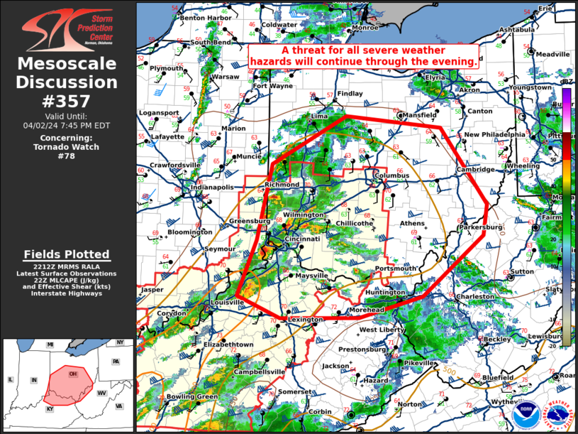
Mesoscale Discussion 0357
NWS Storm Prediction Center Norman OK
1214 PM CDT Sat Apr 04 2026

Areas affected...Sabine Valley into lower Mississippi Valley

Concerning...Severe potential...Watch unlikely

Valid 041714Z - 041915Z

Probability of Watch Issuance...20 percent

SUMMARY...Filtered surface heating of a very moist arimass will
support scattered thunderstorms capable of wind damage this
afternoon. Lack of storm organization should preclude watch
issuance, however.

DISCUSSION...Broken cloud cover is promoting modest surface heating
of a very moist (upper 60s to low 70s F dewpoints) airmass early
this afternoon. With time, additional heating should allow for
scattered thunderstorm development along and ahead of the cold
front. This region exists on the southern fringe of the stronger
mid-level winds, but will have 1500+ J/kg MLCAPE by late afternoon.
25-35 kts of effective shear would support marginally, transiently
organized storms capable of wind damage. Poor mid-level lapse rates
and a linear mode will limit hail potential. There is lingering,
modestly strong 850 mb winds that will be diminishing through the
afternoon. The tornado threat should be low and conditional in the
short-term and decreasing with time.

..Wendt/Gleason.. 04/04/2026

...Please see www.spc.noaa.gov for graphic product...

ATTN...WFO...MEG...JAN...LZK...LCH...SHV...HGX...FWD...

LAT...LON   30979636 31989598 33399367 34279100 34728917 34308836
            32229001 30919255 30479412 30549581 30649617 30979636

MOST PROBABLE PEAK TORNADO INTENSITY...UP TO 95 MPH
MOST PROBABLE PEAK WIND GUST...UP TO 60 MPH
Read more